I returned the following Sunday, with a goal of 1. finding my phone and 2. finding the Atir mine. As I drove into the Floridas I was greeted by a chorus of rifle fire from scattered hunters, most seemingly too close to the road for comfort. As I drove away from this haphazard gathering of outdoors men, I had to ask, why after taking the first shot and missing, would you immediately follow with 7-8 more shots in rapid succession? Any game that was in the vicinity, was making tracks, for safety's sake, as did I. Driving towards Lobo Draw with gunfire echoing off the hills, I had to fight the urge to cringe or duck down the entire way. At English Well I found a group of hunters had set up camp, after driving past them, I put the truck in reverse and went back to their camp. Having seen the trigger happy yahoos down below, I thought it would be wise to let these gentlemen know that I was in the vicinity. The group was from Albuquerque, quail hunters, which would explain the birds I had seen blown to bits alongside the road. I gingerly walked up to their camp, and introduced myself "Good Morning, I'll be hiking along the draw towards the box canyon" they were neither friendly nor unfriendly, slightly bothered, as I expected them to be, that I had walked up on their camp. I talked to one gentleman, who asked about a white feature on the mountainside, he asked "Is that a camping trailer up there?" I had asked myself the same question earlier in the week, while peering at it with binoculars. "I don't know" I told him "But I'll be up there later this morning to find out" he then asked me "What are you hunting?" to which I answered "My Cell phone" which got a laugh from the group, one man then added "Good luck with that one." I then continued on to the trail, I re-traced my steps, knowing the phone wasn't in the finger draw. When I got to the clearing I did a quick sweep of that area, nothing, I then started up the slope towards a large tailing dump, nothing, I found the game trail I had followed up the slope, as I went along, something caught my eye, and just like that, there it was, my phone still in its black case, no worse for wear.

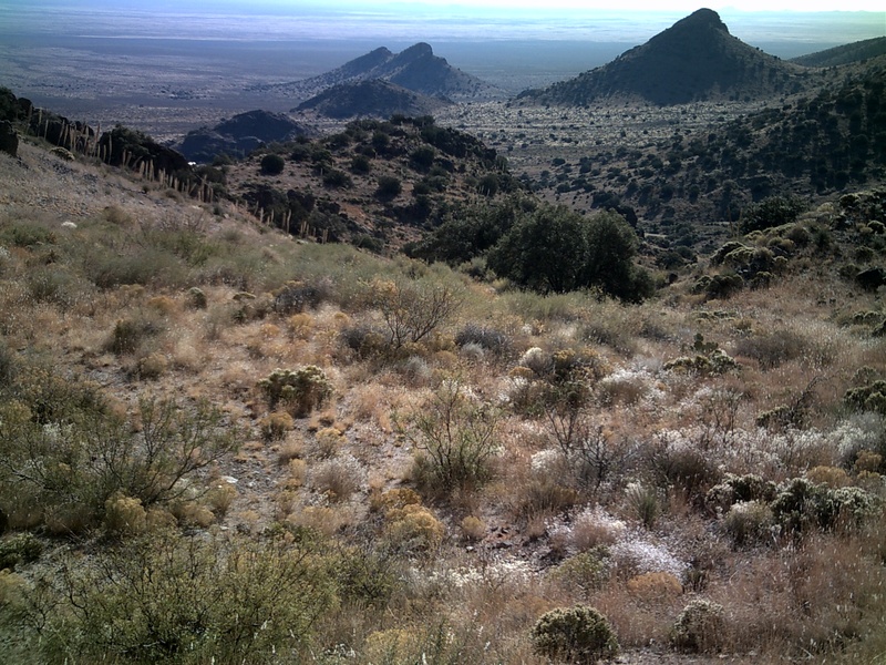
From my vantage point, I realized that just below me was the trail that follows the draw from English Well, I worked my way down and found it was actually an abandoned road. Conveniently, this path led to the white object that had intrigued us earlier, as I approached, I saw that it wasn't a travel trailer, it looked like a small dwelling. Just below me, the draw had grown to a canyon dropping off steeply. Then as I came around the last turn, A massive head-frame and timber hoist came into view, the white building was actually a concrete holding tank, painted white, below it, hanging precariously was a long abandoned privy. The site was quite build-up with a ranch house (parts of which were still under roof) work shops, foundations and a large scattering of debris. The mine works were layed out on a fairly level spot near the head of the draw, to the west the rock cliffs rise towards the sky, to the north the draw drops down a couple hundred feet. The tin metal buildings stepped up the slope from the ranch house, judging from the infrastructure you would expect a large mine opening with an extensive network of shafts or tunnels. However all I found was one modest opening that was back-filled. The task of hauling the large timbers up the mountain was monumental, all that work and expense for so few results, it didn't add up. I found conflicting information regarding the name of the mine, the longitude and latitude coordinates, identify it as The Lobo mine, however The Anniversary mine has very similar coordinates. Information scrawled on the ranch house walls dates the mine's start-up at 1943. Below a long list of names, someone wrote: Target mine Anniversary. I'm not sure if this refers to the name of the mine or if these people gathered here to mark some sort of anniversary. Debris and materials found at the sight would indicate that work took place up until the mid- 1970's. The years of production, recorded for both the Lobo & Anniversary mines are very similar, while I've found no mention of a Target mine. With sunlight fading, I started back down the trail, I had not found the Atir mine, I had found my phone and I had solved the mystery on the mountainside.

The Florida Mountains are rugged, too often people underestimate just how rough the terrain is and find themselves in trouble. The range doesn't give up it's secrets easily, it can test the vigor and skills of anyone. In 2010, two search and rescue missions were necessary to pull injured or stranded hikers out of the Spring Canyon area. Hiking in the Floridas should be accompanied by a healthy amount of respect and apprehension. There are days that we just don't have it, on my third trip into Lobo Draw, I didn't have it, my legs felt heavy as I started up the trail. I pushed on telling myself that it would be Ok as long as I didn't burn energy needlessly. When I got to the head of the trail, I had the option of working my way slowly along the ridge of a nearby hill or plowing straight ahead. I made the wrong choice and quickly found myself funneled into a draw, where I had to fight through a tangle of brush. After a thirty minute struggle to reach a nearby crest, I realized it was a dead end. Returning to the trail, I decided that if I can't climb over, I'll climb around the mountain. I worked my way south, finally reaching another crest, that was also a dead end. While retracing my steps, I stepped on some loose dirt and went down, landing on my seat. The mountain was winning, I sat there for awhile, allowing the futility of my efforts to sink in. They had dug a 775ft. long adit into the mountain, they got up there somehow, yet I could not find a road or path leading to the elevated slopes above me. After a lunch break, I worked my way across two draws and up another hill, from there I could search for Ibex along the high slopes. I did not spot the elusive mountain goats, but something did catch my eyes. High on the mountain, I saw two tailing dumps, they were about 100 yards apart, the small one being the Atir Mine and the large one The Waddell Prospect. I had finally spotted the mines, however my heart sank as I realized how hard the climb would be. Both mines sit at about 6200 ft., climbing up on a smooth slope, it would be possible. In the Floridas nothing is that easy, as ravines, brush and cactus impede your progress. I sat there with my binoculars trained on the mountain side when it dawned on me, I can't get up there. I don't know how they got the equipment to the two mines, maybe they flew the larger pieces in by helicopter. Did the miners camp at the site, did they commute, if they did, where is the damn road? As the most isolated and hard to reach place in Luna County, Atir could just as well be Kashmir.

No comments:
Post a Comment